In order to develop a prototype Innovative “met-ocean” IS for Offshore Wind and Ports Operations, as starting point, SeaTopic and BrestPort worked on the state of the art “ e-navigation models” produced by the IHO ii/IMOiii. These models have been designed to provide mariners, ports, Offshore industry an access to time dependant information such as environmental data (tides, waves, currents, wind, AIS). This data set, unless AIS, is not currently accessible in real time on the users’ terminals: ECDIS on board vessels, VTS in harbour master’s office or surveillance stations, PPU (mobile terminals used by the maritime pilots). The related “e-navigation” standards (S-100) are still under development but basic data sets are almost finalised and the user terminals exist as prototypes. DIOL is supposed to develop models that will be further exploited by the OW communities. Thus the decision to base the DIOL “met-ocean” information service on standards has been taken and more precisely the use of Swthe S-100 standard is a requirement.
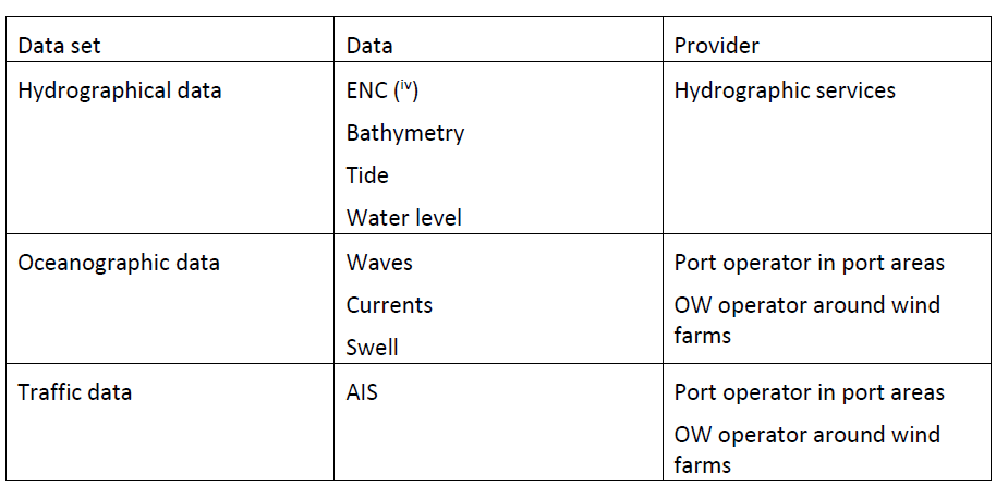
The minimum set of data that should be provided by the MetOcean IS are:
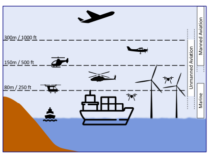
Moreover, for the OW industry, the same information system could/should be used to secure air (drones) and maritime logistics & surveillance means. The impact on the specification has been further studied with the maritime and drone communities and decision makers (the IHO ii) during the preparation of the specification document. This may require evolutions of the e-navigation standard in order to (ad minimum) enable ships/ VTS stations to get and to visualise drones’ information. This “drone information” is not part of the core specifications. It may be an additional functionality based on a requirement: “no integrated surveillance/ operation information system can be setup without exchange between sea and drone components of the OW logistic chains. SeaTopic analysed with Frauenhofer Institute and Brittany Aviation how to integrate drones / aerial and maritime traffic information. On the maritime segment, such a system would possibly use the S-100 model of e-navigation with an additional "drone" information layer to visualise drone information on the user terminal.
See publication (contribution to the Hydro 2024 international conference): Fusing navigation: ECDIS, drones flights and aviation by Gunnar Tietze (SeaTopic SAS), Fabienne Vallée (BrestPort) & Tim Strohbach (IFAM Fraunhofer).