
Shared mobility has become a familiar concept and is now an integral part of our urban landscape. The Dutch province of Utrecht also sees opportunities to scale up shared mobility in both urban and rural areas. But do we actually have a clear overview of the current locations where shared vehicles are available? Can we identify spatial patterns and clusters in the shared mobility offerings? And when can we consider something to be a shared mobility hub? As a partner of the Interreg-project ‘ShareDiMobiHub’, Hogeschool Utrecht conducted an inventory and GIS-analysis of shared vehicles and shared mobility hubs in the province of Utrecht.
Maps of the Mobility Hubs in Utrecht
By Gido Stoop, Karla Münzel, Martijn Rietbergen & Frans Bal, Centre of Expertise Smart Sustainable Cities, Hogeschool Utrecht
As part of the Interreg-Project 'ShareDiMobiHub' (Shared & Digital Mobility Hubs), the Province of Utrecht is working on an upscaling plan for shared mobility in the province. When drafting this upscaling plan, it is important to have a comprehensive overview of the current offerings in the province. Contracts with providers of shared mobility are often made at the municipal level. This approach poses challenges at the provincial and national levels. Data on the use of shared mobility is often difficult to obtain or lacks transparency. Additionally, it complicates cooperation at the inter-municipal level. This is one of the bottlenecks in promoting an integrated offering of shared mobility in the province. The data used in this research was obtained entirely from the websites of the providers of shared vehicles and CROW (knowledge platform on Dutch infrastructure, public space, traffic, and transport).
As part of the Interreg-Project 'ShareDiMobiHub' (Shared & Digital Mobility Hubs), the Province of Utrecht is working on an upscaling plan for shared mobility in the province. When drafting this upscaling plan, it is important to have a comprehensive overview of the current offerings in the province. Contracts with providers of shared mobility are often made at the municipal level. This approach poses challenges at the provincial and national levels. Data on the use of shared mobility is often difficult to obtain or lacks transparency. Additionally, it complicates cooperation at the inter-municipal level. This is one of the bottlenecks in promoting an integrated offering of shared mobility in the province. The data used in this research was obtained entirely from the websites of the providers of shared vehicles and CROW (knowledge platform on Dutch infrastructure, public space, traffic, and transport).
The Shared Mobility Hub
The aim of this research is to create a comprehensive overview of locations where shared vehicles are available. Additionally, it has been investigated to what extent these shared vehicles cluster into shared mobility hubs. In this research, a 'shared mobility hub' is defined as a location where at least two different forms of shared mobility and/or public transportation stations are within close proximity (150m) of each other. Shared mobility hubs serve as central points in multimodal travel, allowing users to easily switch between different (shared) modalities. The most well-known example of this is train stations with public bicycle hubs, often used for the so-called 'last mile' of the traveler. In this inventory, active efforts were made to identify hubs that are not officially designated as hub locations.
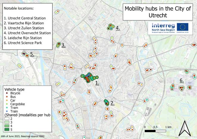
100 hubs in the Province of Utrecht
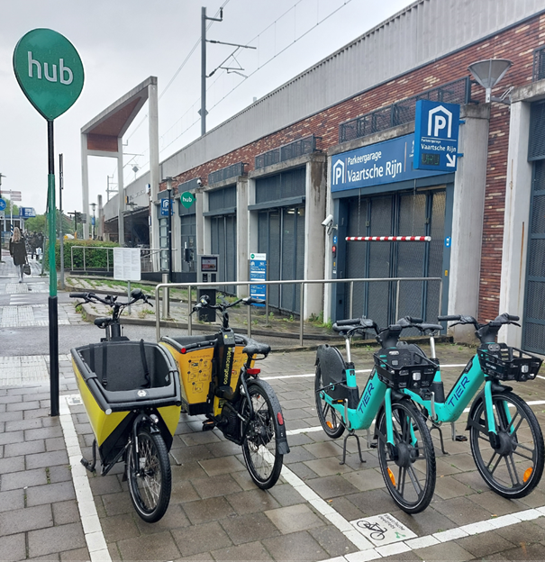
In total, approximately 3,642 shared vehicle locations were mapped in the province of Utrecht (1,834 cars, 1,520 (cargo) bikes, 288 scooters), each location having at least one, but sometimes multiple shared vehicles. In addition to the shared vehicle locations, the goal was to also identify hubs. For the cluster analysis, only shared vehicles with a fixed location and two or more shared vehicles were considered. The identified hubs in the municipality of Utrecht are visible on the map. It is immediately noticeable that hubs with the most diverse modalities are located near train stations. This is also the case for the rest of the province, where hubs can be found at train stations and major bus stations. Additionally, multiple hubs were mapped at Park and Ride (P+R) locations. In total, 100 hubs were mapped in the province of Utrecht. In the case of the municipality of Utrecht, there are official hub locations designated by the municipality, such as at Utrecht Vaartsche Rijn Station. These official hub locations are designed according to the national 'hub' identity, including a green sign with the 'hub' logo. It is noteworthy that Utrecht Central Station, Utrecht Zuilen Station, and Utrecht Overvecht Station are not (yet) official hub locations, despite significant clusters of (shared) modalities being identified there.
The most common combinations of modalities are train-bus-bicycle hubs (17 times), bus-bicycle hubs (17 times), and bus-car hubs (22 times). Providers such as OV-bike (asset of a Dutch train operator) and Keobike (asset of two bus operators) play an important role in the formation of train-bus-bicycle hubs and bus-bicycle hubs. Due to the widespread presence of bus stops and shared cars in the province, bus-car hubs are the most frequent. However, the location of shared cars is not limited to public transportation stops. One possible explanation is that the connection with public transportation is less important for shared cars because they are less frequently used for 'first- and last-mile' travel, but instead are used for uni-modal door-to-door trips.
What can we do with these results?
The map of locations and hubs of shared mobility and public transportation provides insight into the current situation of shared mobility and can be used to support the development of new policies. Furthermore, it shows that it is possible to gain insight into the supply of shared mobility without delving deep into various municipal sources. Taking into account the presence of shared mobility providers in other provinces, a similar study could be conducted there as well.
The inventory of hubs is just a first step in providing guidance to policymakers in the mobility domain. In the next phase of the project, this inventory will be used to identify new potential hub locations based on factors such as visibility, connectivity, and accessibility of the locations. A GIS approach will also be used for this purpose.
Finally, the province of Utrecht will use this information to develop and implement a provincial plan for the upscaling of shared mobility, aimed at creating an inter-municipal network of shared mobility hubs.
For more information or questions, you can contact gido.stoop@hu.nl