
How can we ensure that evacuation is possible during a crisis and that the roads do not become congested? Take Zeeland, for example: when a flood hits, there are not many roads to leave the province, how to make sure that everyone evacuates safely? That is where the evacuation analyses tool comes in.
A new digital tool for evacuation planning
You may have seen it on the Dutch news: a new smart digital tool designed to support evacuation planning during crises. Safety Region Zeeland, FIER project partner; Fieldlab Zuid6, a collaborative innovation initiative of six safety regions; Technical University Delft; and Argaleo, a geo-software developer, jointly developed this smart evacuation analysis tool.
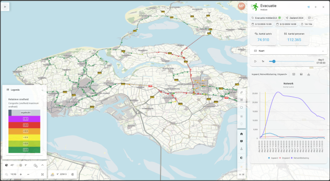
Deciding when and how to evacuate during a crisis is a complex challenge. The evacuation analyses tool supports decision-makers in making this tough decision by providing knowledge about the most efficient evacuation routes. And informing them about the timing of the decision, showing whether there is still enough time to evacuate safely or if it is safer to advise people to take shelter in place. By visualising and analysing multiple evacuation scenarios and showcasing realistic traffic flows, the tool also helps emergency services anticipate and manage potential bottlenecks during an evacuation.

Pilot testing in Zeeland
The evacuation tool was tested in Zeeland as a pilot on the scenario of flooding. Marcel Matthijsse of Veiligheidsregio Zeeland explains that it is a valuable aid in developing evacuation plans. The tool is expected to change a lot, as previously these estimations and calculations were all done manually. So far, the tool already gave some interesting insights; Matthijsse notes that more vehicles can fit on the A58 (one of the main roads out of the province) than initially expected. The tool also revealed that roundabouts and toll gates create delays during an evacuation.
The tool will continue to evolve, incorporating more data and new functionalities. Future options include adding emerging infrastructures, such as temporary emergency solutions like pontoon bridges, and integrating building height information to assess when it is safer to evacuate or to move to higher floors for shelter. It can also be connected with additional models, including weather models, to continuously recalculate and update evacuation scenarios in real time. Now delivered as a minimal viable product, the tool will be tested in other regions and applied to different scenarios, such as wildfires and power outages.
The information provided by this tool is a key component of the decision support tool being developed as part of the FIER project. In addition, the evacuation tool directly contributes to FIER's goal of enhancing the emergency response of crisis management organisations, helping them better prepare for and manage evacuations during climate-induced flood events.